Click to Enlarge Imagetzu),
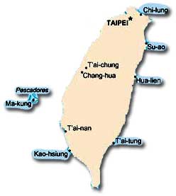
Location: Taiwan is located in East Asia and situated on two
strategic straits, the Taiwan Strait, facing the southeastern coast
of China, and the Luzon Strait, which connects the Pacific Ocean
with the South China Sea north of the Philippines. Besides the
island of Taiwan and six small islands that appertain to it off the
Pacific Ocean (east) coast, the government also controls the
P’eng-hu Islands (64 islands southwest of Taiwan in the middle
of the Taiwan Strait, also known as the Pescadores). On the west
side of the Taiwan Strait, Taiwan controls Kinmen (12 islands,
also rendered as Chin-men, Jinmen, and Quemoy), 182 nautical
miles west of Taiwan; and Matsu (10 islands, also rendered Ma-
114 nautical miles west of Taiwan. Both Kinmen and Matsu appertain
to China’s Fu-chien (Fujian) Province. Taiwan also has effective jurisdiction over the Tung-sha (Dongsha or Pratas) Islands and Taiping Island (Ita Abu Island) in the Nan-sha (Spratly Islands) in the South China Sea.
Size: Taiwan’s total area is 35,980 square kilometers, of which 32,260 square kilometers are land and 3,720 square kilometers are water.
Land Boundaries: Taiwan and other islands under its jurisdiction have no land boundaries.
Length of Coastline: The total coastline of Taiwan measures 1,566 kilometers. The East China Sea is to the north, the Pacific Ocean is to the east, the Philippine Sea is to the southeast, the South China Sea is to the southwest, and the Taiwan Strait is to the west.
Maritime Claims: Taipei claims a territorial sea of 12 nautical miles and an exclusive economic zone of 200 nautical miles. Taiwan is involved in a complex dispute with China, Malaysia, Philippines, Vietnam, and possibly Brunei over islands in the South China Sea. These include the Nan-sha (Spratly) Islands, Hsi-sha (Sisha or Xisha, Paracel) Islands, Tung-sha (Dongsha, Pratas) Islands, and Chung-sha (Zhongsha, or Macclesfield Bank) Islands. Taiwan and China also lay claim to a small archipelago 75 nautical miles northeast of Taiwan, called Tiao-yü T’ai (or Diaoyutai; known to Japan as the Senkaku Islands), which are under Japanese administration.
Topography: The eastern two-thirds of Taiwan, facing the East China Sea and Pacific Ocean, is mostly rugged mountains, which run north to south and cover about 63 percent of the island. The T’ai-tung Mountains in the east have an average elevation of 1,000 meters. The Chung-yang Shan (Central Mountains) range dominates the island, with some 200 peaks that exceed 3,000 meters. The highest point at 3,952 meters above sea level is Yü-shan (Jade Mountain, also known as Mount Morrison) in the Yü-shan Shan Mountains (Jade Mountains), on the southwest side of the Chung-yang Shan Mountains. Volcanic peaks are found in the Ta-t’un Shan Mountain area near Chi-lung (Keelung) and Taipei. To the west of the Chung-yang Shan are rolling hills that descend to gently rolling alluvial plains and the Taiwan Strait. This relatively flat region extends some 300 kilometers north to south but is no wider than 50 kilometers at its broadest reach. The lowest point is zero meters above sea level along parts of the coast.

Click to Enlarge Imagetzu),
Principal Rivers: Taiwan has some 151 rivers and streams with short, steep descents on the east side of the island and longer but still steep descents into the western alluvial plains. The Cho-shui River is the longest at 187 kilometers, with a drainage basin of 3,157 square kilometers. The 171-kilometer-long Kao-p’ing River has the largest drainage basin (3,257 square kilometers). The Taipei Basin is drained by the 159-kilometer-long Tan-shui River, which once was deep enough for ocean-going sailing ships but now is restricted to shallow-draft boats.
Climate: The climate is tropical and marine. There is a rainy season during the southwest monsoon, from June to August. Cloudiness is persistent and extensive year-round. Typhoons regularly hit Taiwan during July to September each year. The lowest monthly average rainfall is normally in November, at 66 millimeters; the greatest is in August, with 305 millimeters. Most rain falls between May and October, and the driest months are between November and February. The mean annual rainfall in the Taiwan area is 2,483 millimeters, with heavier rainfalls in the north and south and slightly lower levels in the east and central regions. Average temperatures range between 12E C and 18E C in the coldest month (February) and 24E C to 33E C in the hottest month (July).
Natural Resources: The most important natural resources are small deposits of asbestos, coal, limestone, marble, and natural gas.
Land Use: Twenty-four percent of the land is arable but has been diminishing since the late 1970s as a result of urbanization and industrialization. About 1 percent of the land is planted to permanent crops. The rest is categorized as “other.”
Environmental Factors: Because of its location at the junction of the Manila Trench and the Ryukyu Trench along the west side of the Philippine Sea plate, Taiwan is susceptible to earthquakes. Large earthquakes occurred in Taiwan in 1935, 1986, and twice in 1999. Seasonal typhoons sometimes cause violent weather conditions leading to death and destruction. Five decades of rapid industrialization have caused considerable environmental damage to Taiwan. The resulting major concerns are air pollution, water pollution from industrial emissions, raw sewage, contamination of drinking water supplies, trade in endangered species, and low-level radioactive waste disposal. Taiwan’s rivers are heavily polluted near the coast. The government’s Environmental Protection Agency monitors environmental problems and requires environmental impact assessments from industrial and other potential polluters.
Time Zone: Taiwan is in one time zone (Asia/Taipei), 8 hours ahead of Greenwich Mean Time.