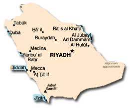
Click to Enlarge Image
Location: Saudi Arabia is located in the Middle East, occupying
about 80 percent of the Arabian Peninsula.
Size: The land area is estimated at between 2,149,690 and 2,240,000
million square kilometers—approximately one-fifth the area of the
continental United States. Border disputes and undemarcated borders
make determining the exact size of the country difficult.
Land Boundaries: Saudi Arabia has a total of 4,431 kilometers of borders with Yemen (1,458 kilometers), Iraq (814 kilometers), Jordan (744 kilometers), Oman (676 kilometers), the United Arab Emirates (457 kilometers), Kuwait (222 kilometers), and Qatar (60 kilometers).
Disputed Territory: Only portions of the border with Yemen, demarcated in 1934, are clearly defined. The discovery of new oil repositories in the 1990s led to border disputes between Saudi Arabia and both Yemen and Jordan, some of which were resolved in the early 1990s. However, conflicts over national borders persist in the Arabian Peninsula.
Length of Coastline: Saudi Arabia has 2,640 kilometers of coastline—nearly 1,800 kilometers along the Gulf of Aqaba and the Red Sea and the remainder along the Persian Gulf.
Maritime Claims: Saudi Arabia claims a territorial sea of 12 nautical miles and a contiguous zone of 18 nautical miles. Saudi Arabia also claims some small islands, seabed, and subsoils beyond the 12 nautical mile limit.
Topography: The Arabian Peninsula is an ancient massif composed of stable crystalline rock whose geologic structure developed concurrently with the Alps. Geologic movements caused the entire mass to tilt eastward and the western and southern edges to tilt upward. In the valley created by the fault, called the Great Rift, the Red Sea was formed. On the Arabian Peninsula, the eastern line of the Great Rift fault is visible in the high escarpment that parallels the Red Sea between the Gulf of Aqaba and the Gulf of Aden. The eastern slope of the escarpment is relatively gentle. A second, lower escarpment, the Jabal Tuwayq, runs north to south through the area of Riyadh. In the south, a coastal plain rises gradually from the sea to the mountains. The central plateau, Najd, extends east to the Jabal Tuwayq and slightly beyond. A long, narrow strip of desert known as Ad Dahna separates Najd from eastern Arabia, which slopes eastward to the sandy coast along the Persian Gulf. North of Najd, a larger desert, An Nafud, isolates the heart of the peninsula from the steppes of northern Arabia. South of Najd lies one of the largest sand deserts in the world, the Rub al Khali.

Click to Enlarge Image
Principal Rivers: Saudi Arabia has no permanent rivers. However, in eastern Arabia, artesian wells and springs provide valuable water resources. Additionally, in many areas of northern and eastern Arabia significant underground aquifers lie beneath the Saudi desert. The largest of these aquifers, the Wasia, contains more water than the entire Persian Gulf.
Climate: The climate in Saudi Arabia differs between two distinct regions: the coast and the interior. Arid and extreme temperatures characterize the interior, and high humidity coupled with more moderate temperatures is prevalent along the coast. Temperatures along the coast rarely rise above 38° C. There is often mist during the day and a warm fog at night. Late spring and early summer in the coastal regions bring the windy season. The interior of Saudi Arabia is composed of desert regions with extreme temperatures. The average daytime temperature in the summer is 45° C, but it is not uncommon for temperatures to reach 54° C. Winter nights can get relatively cold, but temperatures rarely drop below freezing. Most of Saudi Arabia receives only infrequent rainfall. However, the southwestern province of Asir experiences monsoons between the months of May and October, when an average of 300 millimeters of precipitation falls.
Natural Resources: Saudi Arabia’s vast oil resources have shaped the kingdom’s development. The country also has large natural gas reserves, as well as deposits of bauxite, coal, copper, gold, iron, phosphates, platinum, silver, tungsten, uranium, and zinc. Non-mineral resources include limestone, glass sand, and stone.
Land Use: Most of Saudi Arabia consists of arid or semi-arid land. According to 2001 statistics, only 1.67 percent of Saudi land can be classified as arable, and only 0.09 percent of land was planted with permanent crops. Irrigated land totaled an estimated 16,200 square kilometers in 1998. In the more temperate regions of the kingdom, adequate forage exists to support cattle grazing.
Environmental Factors: Saudi Arabia faces numerous environmental challenges. In addition to having very little arable land, desertification and creeping sands are a concern, as is water scarcity. The lack of perennial rivers or permanent bodies of water poses a continual challenge, as does the depletion of underground water resources. Additionally, coastal oil spills, though infrequent, contribute to pollution.
Time Zone: Saudi Arabia operates on Greenwich Meantime plus 3 hours.